
Overview
- Pit-constrained Initial Inferred Mineral Resource Estimate released January 19, 2023 consisting of 1,340,000 ounces of gold* contained in two near/on-surface zones: the Blackjack and Eiger gold deposits
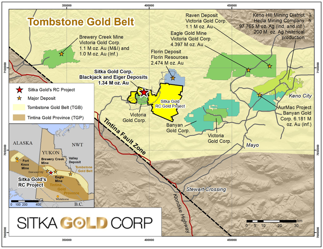
- A district-scale, contiguous land package covering 376 square kilometres with multiple intrusion related gold deposit targets located in the heart of the Tombstone Gold Belt in Yukon.
- Blackjack deposit contains a higher grade resource of 900,000 ounces of gold at a grade of 0.83 g/t gold with a cut-off grade of 0.25 g/t gold.
- The deposits are open in all directions and are located at opposite ends of a 2km long mineralized corridor running East-West which remains relatively untested but has been shown to contain significant gold mineralization with the potential to add additional resources.
- Best drill results to date released September 26, 2023: 219.0 m of 1.34 g/t gold including 124.8 m of 2.01 g/t gold at RC Gold, Yukon. (NR 23-27)
- Bonanza grade intercepts in Hole 46 announced September 11, 2023, revealed 4.3 m of 33.10 g/t gold including 1.2 m of 108.00 g/t gold (NR 23-26)
- Initial metallurgical testing indicates that the gold is not refractory and has high gold recoveries of up to 94% with minimal NaCN consumption (see News Release dated July 13, 2022).
- The project has year-round road access with close proximity to key infrastructure such as power lines, the Klondike Highway and Dawson City.
- Several high priority intrusion related gold deposit targets remain untested across the property and have the potential to host additional gold deposits.
Simpson, R. January 19, 2023. Clear Creek Property, RC Gold Project, NI 43-101 Technical Report, Dawson Mining District, Yukon Territory.
The RC Gold Project, comprised of the RC Gold, Mahtin, Clear Creek and Barney Ridge properties, is a district-scale, contiguous land package of 1,891 claims covering approximately 376 square kilometres (37,600 hectares or 92,900 acres) within the geologically fertile and highly prospective Tombstone Gold Belt (TCB) region (Figures 1 & 2). The 1.34 million ounce deposit at the RC Gold Project is an intrusion-related gold deposit similar to other intrusion-related gold deposits that exist throughout the Tombstone Gold Belt such as Victoria Gold’s Eagle and Olive Deposits (with a combined 4.7 million ounces Au) (1), Victoria Gold’s Brewery Creek Deposits (1.5 million ounces gold) (2), Florin Resources Florin Gold Deposit (2.47 million ounces gold) (3) and Banyan Gold’s AurMac Project (3.99 million ounces gold) (4). Numerous placer gold deposits also exist throughout this gold-rich belt. The Tombstone Gold Belt is located within the larger Tintina Gold Belt which also hosts Kinross Golds’ Fort Knox deposit in Alaska (3 million ounces of gold) (5) (see Figure 1). Several additional intrusion related gold deposit targets a present across the RC Gold Project but have yet to be tested as the initial focus has been at the Blackjack and Eiger zones.
- https://vgcx.com/development/eagle-gold-project/reserve-resource-statement/
- https://vgcx.com/news/victoria-gold-acquires-yukon-properties-brewery-creek-1.1m-ozs-of-m-i-and-1.0m-ozs-of-inferred-gold-resources/
- http://stjamesgold.com/st-james-gold-corp-is-pleased-to-announce-updated-resource-on-the-florin-gold-project-yukon-with-an-inferred-resource-of-2474000-oz-of-gold/
- https://www.banyangold.com/news-releases/2022/banyan-announces-4-million-ounce-gold-mineral-resource-estimate-for-the-aurmac-property-yukon-canada/
- https://www.kinross.com/operations/#americas-fortknox
Location
The RC Gold Project is situated about 100 km east of Dawson City, Yukon at the headwaters of Clear Creek and Big Creek, a major placer mining district that is serviced by a network of gravel roads and trails. A new, well maintained placer mine access road traverses through the south side of the claim block and provides great access across the Property (Figure 2). This road connects to the Clear Creek road which connects to the Klondike Highway, approximately mid-way between Stewart Crossing and Dawson (Figure 1). The contiguous RC Gold Project claim block is strategically located within the heart of the Tombstone Gold Belt and is surrounded by junior mining companies, including Snowline Gold, Victoria Gold, Florin Resources and Banyan Gold.


Initial Mineral Resource Estimate
On January 19, 2023 Sitka Gold announced an Initial Mineral Resource Estimate prepared in accordance with National Instrument 43-101 (“NI 43-101”) guidelines for the RC Gold Property of 1,340,000 ounces of gold. The road accessible, pit constrained Mineral Resource is classified as inferred and is contained in two near/on-surface zones: The Blackjack and Eiger deposits. The Mineral Resource estimate is presented in the following table at a base case cut-off grade of 0.25 g/t Au:
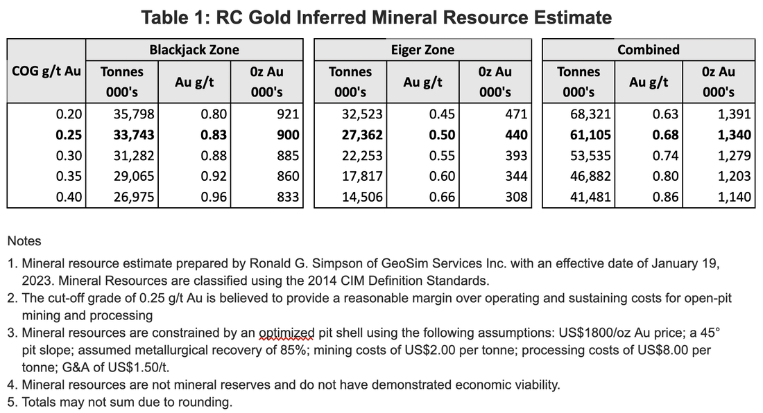

The Initial Mineral Resource Estimate of 1,340,000 ounces of gold at the RC Gold Project is comprised of two deposits: the Blackjack deposit containing 900,000 ounces of gold at a grade of 0.83 g/t gold and the Eiger deposit containing 440,000 ounces of gold at a grade of 0.50 g/t gold (see news release dated January 19, 2023). Both of these deposits are at/near surface, are potentially open pit minable and amenable to heap leaching, with initial bottle roll tests indicating that the gold is not refractory and has high gold recoveries of up to 94% with minimal NaCN consumption (see News Release July 13, 2022).
The Blackjack and Eiger deposits are in close proximity to highway and power infrastructure, are road accessible year-round, remain open in all directions and are respectively located at the western and eastern end of a large, 500 metre by 2 kilometre intrusion related gold system that was recently discovered on the Property. As of March 1, 2023 just 38 diamond drill holes have been drilled into this system for a total of approximately 13,000 metres with results of up to 201.0 m of 1.26 g/t gold from surface, including 82.0 m of 2.04 g/t gold and 19.5 m of 4.87 g/t gold at Blackjack (drill hole DDRCCC-22-040; see news release dated January 11, 2023) and 354 m of 0.41 g/t gold including 72 m of 0.72 g/t gold at Eiger (drill hole DDRCCC-21-09; see news release date August 19, 2021).

Several high priority intrusion related gold targets exist at RC Gold with nine outcropped intrusions identified to date over the 376 sq km property, however Sitka’s main focus at the RC Gold Project has been on the underlying Clear Creek Property where a large 500 metre by 2000 metre intrusion related gold system covering the area over the Blackjack, Saddle and Eiger zones was identified. To date the Company has drilled 38 diamond drill holes into this system for a total of approximately 13,000 metres. This drilling culminated in the discovery of the Blackjack and Eiger deposits with an initial inferred mineral resource estimate of 1,340,000 gold ounces(1).
Sitka Gold inherited a wealth of historical and current data from these properties from work spanning the last 40 years. Recent exploration work and the compilation of historical data have defined several mineralized zones with both bulk tonnage, intrusion-related gold deposit targets and high-grade, vein- and breccia-hosted gold targets. The RC Gold Project also has a common border with Victoria Gold’s Clear Creek property at its western boundary and Florin Resources’ Florin Gold property at its northern boundary.
Recent Results
Sitka has completed 16 drill holes, totaling approximately 6,515 metres, as part of its 2023 diamond drill program at RC Gold
2023 Drilling Highlights:
- DDRCCC-23-047 – 219.0 m of 1.34 g/t Au from 190.0 m including:
- 124.8 m of 2.01 g/t Au from 233.0 m including:
- 55.0 m of 3.11 g/t Au from 276.0 m including:
- 14.0 m of 5.53 g/t Au from 311.0 m
- DDRCCC-23-046 – 56.0 m of 1.23 g/t Au from 134.0m and:
- 38.2 m of 4.15 g/t Au from 320.8 m
- DDRCCC-23-043 – 449.0 m of 0.74 g/t Au from 4.0m (surface) including:
- 14.0 m of 3.28 g/t Au from 345.0 m
- 9 holes currently pending assays

DDRCCC-23-046 – Bonanza Grade Intercepts
- 56.0 m of 1.23 g/t Au from 134.0, incl.
- 6.2 m of 2.50 g/t Au from 141.2 m, and
- 9.6 m of 2.81 g/t Au from 168.0 m and
- 38.0 m of 4.15 g/t Au from 320.8 m, incl.
- 4.3 m 33.10 g/t Au from 326.1 m, incl.
- 1.2 m of 108.00 g/t Au from 327.8 m

- 219.0 m of 1.34 g/t Au from 190.0 m including:
- 124.8 m of 2.01 g/t Au from 233.0 m including;
- 55.0 m of 3.11 g/t Au from 276.0 m including:
- 14.0 m of 5.53 g/t Au from 311.0 m


Eiger Deposit Focus of 2021 Drilling, 2023 Resource Expansion:
- Eiger Deposit focus of 2021 drilling resulting in initial resource estimate
- DDRCCC-21-09 intersected 354 m grading 0.41 g/t Au including 72.0 m grading 0.72 g/t Au


Priority 1
Follow-up step-out drilling from Hole
DDRCCC-23-047 planned for Fall/Winter 2023/24 drill program focused on testing this higher grade gold system that is open to the south, east, west and to depth.
Priority 2
Test drilling additional targets within the Northern Clear Creek Intrusive Complex including follow-up drilling based on drill results from 9 drill holes still pending.
Priority 3
Test drilling of 5 additional intrusion-related, drill-ready targets refined to date.
Priority 4
Further refine 28 identified potential intrusion-related drill targets currently within the 376km sq land package at RC Gold.

Project History
Placer Mining first began on Clear Creek in the late 1800’s and the first quartz claims were staked in the early 1900’s. Placer mining has continued to the present, with a dredge operating on Clear Creek from 1943 to 1954 and again between 1981 and 1987. Several active placer mines continue to operate in the Clear Creek drainage and new placer mining activity has recently begun in Big Creek.
The first modern hard rock exploration in the area took place in the 1970’s, targeting silver, tin and tungsten, metals commonly associated with Intrusion Related Gold deposits. High grade gold-silver and silver-lead-zinc veins have also been prospected.
In the 1990’s, exploration shifted to bulk tonnage gold after the discovery of the Fort Knox gold deposit in Alaska, in a similar geological environment. Explorers in and around the vicinity of the RC Gold Project included Noranda, Ivanhoe Goldfields, Kennecott and Newmont. These companies carried out geological mapping, geochemical and geophysical surveys and several campaigns of drilling. More recently, in the 2000s, Thor Exploration, StrataGold, Golden Predator, Pacific Ridge and Kestral Gold have explored on the west side of the RC Project, while Ryan Gold (now StrikePoint) explored to the east. AM Gold’s Red Mountain Property, an intrusion-related gold target that is adjacent to the the Project’s northern border, has also seen exploration throughout the 2000’s and has a resource of 1.95 million of gold ounces defined.
RC Gold Property (RC, BEE & BOP Claims)
In 2017, the RC Gold Property was optioned to Pacific Ridge Exploration Ltd. who completed a program of geological mapping and property-wide soil sampling that same year. Pacific Ridge conducted additional soil sampling, mapping and a small geophysical survey in 2018. These work programs produced encouraging results with several previously unknown gold-in-soil anomalies shown to be present on the Property. In 2019, after acquiring the Property, Sitka Gold followed up on these results with a soil sampling and geophysical survey program designed to expand and fill in the previous geophysical and geochemical anomalous zones that had been identified. Together, this work has defined several high-priority gold targets where the gold values, plus the associated pathfinder metals, are typical of mineralization associated with Intrusion Related Gold deposits. Two of these mineralized zones appear to be contiguous representing an Intrusion Related Gold target that is 2 km long by 0.5 km wide (see Figure 3). In 2020 Sitka completed 2 helicopter supported drill holes in the Big Creek and Far Grid targets and also flew a LiDAR survey across the western half of the Property.

Geological Setting
The area of the RC Gold property is underlain by phyllite, quartzite, calc-phyllite, calc-silicate, grit and marble of the Proterozoic to Early Cambrian Hyland Group. These metasedimentary rocks are imbricated by thrust faults of Jurassic and Early Cretaceous age. The Clear Creek area is in the hanging wall of the Robert Service Thrust.
At the headwaters of Clear Creek, six Tombstone-style intrusions with ages of approximately 92 my, include the Saddle, Eiger, Pukelman, Rhosgobel, Josephine and Big Creek stocks. They have surface exposures ranging from 0.2 to 3.5 km2. The Saddle, Pukelman and Rhosgobel stocks are composed of medium- to coarse-grained quartz monzonite The Josephine and Big Creek stocks are composed of fine- to medium-grained, equigranular granodiorite. The Eiger stock is composed of fine to medium-grained, equigranular diorite with rare mafic phenocrysts.
Contact metamorphism of the Hyland Group country rocks extends for as much as 0.5 km around the stocks and typically occurs as resistant, rusty weathering biotite hornfels.
Mineralization
The RC Gold property lies within the heart of the Tintina Gold Belt. Hart (2005) has estimated a total metal endowment on the order of 70 million ounces of gold. Key deposits include Brewery Creek and the Eagle deposit (Dublin Gulch) in Yukon and Fort Knox, True North, Pogo and Donlin Creek in Alaska. Most of these deposits are characterized by flanking placer gold creeks.
The immediate area of the RC Gold property is characterized by several styles of mineralization associated with the Tombstone-aged intrusions, but the most important of these is sheeted veins, stockworks and breccias that occur within the intrusions and adjacent hornfels. These veins typically contain minor amounts of sulphide, including arsenopyrite, pyrite and rarely pyrrhotite. Other minerals include scheelite (tungsten), molybdenite, galena, chalcopyrite and bismuthinite. Arsenic, bismuth, tellurium, antimony, tungsten and molybdenum are typical pathfinder elements when prospecting for gold in these types of systems.
CLEAR CREEK PROPERTY
- Robust intrusion-related gold system discovered in 2021
- Initial total inferred pit constrained mineral resource of 1.34 million ounces gold (0.25 g/t cut-off) announced January 2023
- Blackjack deposit 900,000 ounces gold grading 0.83 g/t
- Eiger deposit 440,000 ounces gold grading 0.50 g/t
- Both zones open in all directions
- 376 km2 property with 9 under-explored intrusive bodies identified to date
- Road accessible claim block located in Yukon’s fertile Tombstone Gold Belt.
- Similar geology and regional proximity to several intrusion-related gold deposits including Victoria Gold’s Eagle Gold Mine, Golden Predator’s Brewery Creek Gold Mine and AM Gold’s Red Mountain Gold Deposit (located adjacent to Sitka’s RC Gold Project, see Figure 1)*.
- Claims are contiguous to Sitka’s RC Gold Project and Victoria Gold’s Clear Creek Project. Located at the headwaters of Clear Creek, an active and prolific placer gold mining district with several producing placer gold mines operating in and around the area.
- Previous rock samples from trace up to 319.5 g/t gold and previous soil samples from trace up to 4,384 ppb gold (Huber, 2018).
- Significant previous drilling intercepts include 88 m of 0.65 g/t gold and 22 m of 1.24 g/t gold (Huber, 2018).
- Active Class 3 Land Use Permit allows for a variety exploration activities including drilling, trenching and road building.
Property History
The Clear Creek Property has had intermittent exploration conducted since 1981. Previous work on the Property has outlined several highly anomalous and extensive gold in soil trends on the margins of four intrusions. These anomalies all show strong correlations with bismuth, arsenic, tungsten and silver; similar to geochemical signatures seen at Victoria Gold’s Eagle Gold Project (Dublin Gulch) and Kinross’s Fort Knox. Historical rock samples from the Property have returned values from less that 5 ppb up to 319.5 g/t gold (Huber, 2018). Many of the high grade samples collected on the property are from sheeted quartz veins and quartz arsenopyrite veins often found within or on the margins of the intrusions. Additionally, significant gold grades of up to 25.1 g/t gold have been returned from metasediments with disseminations and weak stockworks of pyrite and arsenopyrite. Several significant intervals have also been recorded from the limited drilling and trenching work completed on the Property returning less than 5 ppb up to 2.11 g/t gold over 25 metres from a trench and 0.65 g/t gold over 88 meters (bottoming in 3.0 metres grading 1.296 g/t gold) from RC drilling (Huber, 2018).

2020 EXPLORATION WORK AT CLEAR CREEK
2020 drilling on the Clear Creek property resulted in the discovery of a major intrusion-related gold system at the Saddle-Eiger zone.
Highlights from the 2020 diamond drilling completed at the Saddle-Eiger Zone include:
- 287.0 metres of 0.52 g/t gold from 9.0 to 296. metres (the entire hole) in DDRCCC20-002 including:
- 231.0 metres of 0.61 g/t gold from 65 to 296 metres and
- 100.8 metres of 0.82 g/t gold from 156.4 to 257.2 metres
- 2.0 metres of 16.10 g/t gold from 294 to 296 metres (end of hole DDRCCC20-002 and not included in the above intercepts)
- 139.1 metres of 0.61 g/t gold from 131.9 metres to 271 metres in DDRCCC20-004 including:
- 59.0 metres of 0.88 g/t gold from 212 to 271 metres and
- 37.0 metres of 1.05 g/t gold from 234 to 271 metres and
- 6.6 metres of 1.27 g/t gold from 131.9 to 138.5 metres
The impressive results from the Saddle-Eiger zone are coincident with a large gold-in-soil anomaly target area that is 2 km x 500 m and open in all directions (see figure below).

2021 EXPLORATION WORK AT CLEAR CREEK
In 2021 the Company completed a 15 hole, 5,000 metre diamond drilling program at the Saddle-Eiger Zone (see figures below) on the Clear Creek property resulted in the discovery of a major intrusion-related gold system at the Saddle-Eiger zone.
Highlights from the 2021 diamond drilling assay results at the Saddle-Eiger Zone include:
- 220.1 metres of 1.17 g/t gold from 6.0 to 226.1 metres in DDRCCC-21-021 including:
- 103.2 metres of 1.61 g/t gold from 80.8 metres
- 50.5 metres of 2.08 g/t gold from 120.0 metres
- 20.5 metres of 2.85 g/t gold from 150.0 metres
- 6.1 metres of 4.30 g/t gold from 120.0 metres
- 0.2 metres of 35.70 g/t gold from 80.8 metres and
- 0.5 metres of 9.81 g/t gold from 81.0 metres
- 213 metres of 0.45 g/t gold from 113.0 to 326.0 metres in hole DDRCCC 21-013 including:
- 59.0 metres of 0.62 g/t gold from 267.0 to 326.0 metres including:
- 15.0 metres of 1.25 g/t gold from 299.0 to 314.0 metres.
- 212 metres of 0.41 g/t gold from 265.0 to 477.0 metres in hole DDRCCC 21-014 including:
- 82.0 metres of 0.61 g/t gold from 273.0 to 355.0 metres and:
- 10.0 metres of 1.15 g/t gold from 154.0 to 164.0 metres
- 402.5 metres of 0.40 g/t gold from 39.0 to 441.5 metres in hole DDRCCC 21-010 including:
- 37.8 metres of 1.03 g/t gold from 136.5 to 174.3 metres and,
- 20.3 metres of 1.65 g/t gold from 154.0 to 174.3 metres.
- 23.0 metres of 0.50 g/t gold from 123.0 to 146.0 metres in hole DDRCCC 21-011 including:
- 2.0 metres of 3.58 g/t gold from 144 to 146 metres
- 25.0 metres of 0.67 g/t gold from 25.0 to 50 metres in hole DDRCCC 21-012 including:
- 1.0 metres of 8.89 g/t gold from 39 to 40 metres
- 7.0 metres of 1.20 g/t gold from 166.0 to 173.0 metres in DDRCCC 21-012 including:
- 0.9 metres of 4.42 g/t gold from 172.1 to 173.0 metres.
- 318 metres of 0.45 g/t gold from 18 metres to 336 metres in DDRCCC21-007 including:
- 104 metres of 0.57 g/t gold from 128 to 232 metres and
- 92 metres of 0.61 g/t gold from 262 to 353 metres and
- 32 metres of 1.23 g/t gold from 262 to 294 metres and
- 14 metres of 2.09 g/t gold from 280 to 294 metres and
- 2 metres of 5.49 g/t gold from 284 to 286 metres.
- 354 metres of 0.41 g/t gold from 76 metres to 430 metres in DDRCCC21-009 including:
- 72 metres of 0.72 g/t gold from 76 m to 148 m and
- 12 metres of 1.52 g/t gold from 198 to 210 metres and
- 48 metres of 0.42 g/t gold from 295 to 234 metres and
- 1 metre of 5.74 g/t gold from 295 to 296 metres.
Results at the Saddle-Eiger Zone continue to show the size and richness of this intrusion-related gold system. Results fromDDRCCC21-021 (“Hole 21”) are especially impressive and reflect what is believed to be a structurally controlled, high-grade gold corridor that is running throughout this large gold system. This hole was a 200 metre step-out from any previous drilling. Visible gold was identified in 21 different sections of Hole 21 further reflecting the richness of this gold system. In addition, several rock samples taken after Hole 21 was completed, approximately 100 to 500 m to the south of Hole 21’s collar, returned up to 11.00 g/t gold and define a new area of gold mineralization on surface that significantly expands the corridor west of the Saddle Zone and Eiger Zones and has been named the Blackjack Zone. Placer gold was also newly discovered in the drainage below Hole 21 and the rock samling area – this gold is quite pure and is likely associated with the in-situ gold mineralization from this zone. See figures and images below:


2022 EXPLORATION WORK AT CLEAR CREEK
In 2022 the Company completed a 20 hole, 6,500 metre diamond drilling program that consisted of a Phase 1 winter drilling program and a Phase 2 summer drilling program. The successful completion of the Phase 1 winter drilling program was a milestone for the RC Gold Project as it showcased the ability to operate year-round thanks to the excellent access road with close proximity to the highway – a rare atribute for most northern exporation projects. The Phase 1 program, which was designed to follow up on discovery Hole 21 and better understand the mineralization present at the Blackjack Zone, returned additional significant intervals of gold mineralization and demonstrated that the gold-rich mineralization discovered with Hole 21 was open for expansion. The results from Phase 1 were instrumental in the design of the larger Phase 2 drilling program which employed 3 diamond drills and was focused on step-out drilling in an effort to build tonnage and better understand the parameters of this gold rich zone. Numerous instances of visble gold were observed across several of the drill holes completed and results received to date from the 2022 drilling program have returned some very impressive gold intervals and have significantly expanded the known gold mineralization at the Blackjack Zone while demonstrating the continuity of higher grades (>1g/t gold) within this zone. Gold mineralization at the Blackjack Zone remains open both laterally and at depth.
Metallurgical testing conducted during the 2022 season returned up to 94% gold recovery and demonstrated that the gold mineralization from these two zones is not refractory and has high gold recoveries with minimal NaCN consumption. This is significant as it endorses the potential for an open-pit, heap leach operation with high gold recoveries and this is typically the most economically efficient method of extracting gold from a deposit.
Highlights from the 2022 diamond drilling program assay results at the Blackjack Zone include:
- 273 m of 0.52 g/t Au from 46 m to 319 m in DDRCCC-22-022 including
- 124.0 m of 0.81 g/t Au from 193.0 m,
- 62.0 m of 1.21 g/t Au from 253.0 m,
- 14.0 m of 3.85 g/t Au from 253.0 m,
- 2.0 m of 6.36 g/t Au from 313.0 m.
- 205.8 m of 1.01 g/t Au from surface in DDRCCC-22-023 including
- 91.0 m of 1.61 g/t Au from 46.0 m,
- 1.0 m of 10.95 g/t Au from 47.0 m,
- 1.0 m of 13.65 g/t Au from 68.0 m,
- 1.0 m of 16.8 g/t Au from 125.0 m.
- 107.5 m of 1.44 g/t Au from 4.5 m to 112.0 m in hole DDRCCC-22-024 including
- 66.0 m of 2.11 g/t Au from 16.0 m including,
- 11.0 m of 3.76 g/t Au from 24.0 m,
- 1.0 m of 7.92 g/t Au from 66.0 m and,
- 2.0 m of 35.60 g/t Au from 80.0 m.
- 349.0 m of 0.71 g/t Au from 19.0 m to 368.0 m in DDRCCC-22-025 including
- 221.0 m of 1.01 g/t Au from 25.0 m,
- 48.0 m of 1.63 g/t Au from 111.0 m,
- 20.0 m of 3.08 g/t Au from 109.0 m and,
- 2.0 m of 15.15 g/t Au from 111.0 m.
- 146.6 m of 0.90 g/t Au from surface in DDRCCC-22-030, including
- 33.8 m of 1.42 g/t Au from 2.84 m;
- 116.0 m of 0.65 g/t Au from 27.0 m to 143.0 m in DDRCCC-22-029, including
- 19.0 m of 1.02 g/t Au from 124.00 m;
- 19.0 m of 1.03 g/t Au from 292.0 m in DDRCCC-22-033, and
- 10.1 m of 1.56 g/t Au from 104.6 m;
- 132.1 m of 0.51 g/t Au from 34.9 m in DDRCCC-22-036, and
- 1.1 m of 20.4 g/t Au from 282.9 m;
- 401.5 m of 0.63 g/t Au from 73.0 m in DDRCCC-22-038 including
- 305.2 m of 0.78 g/t Au from 79.8 m depth, and including
- 180.0 m of 1.04 g/t Au from 176.0 m depth


BARNEY RIDGE PROPERTY
Property Highlights
- 92 quartz claims totalling approximately 1000 hectares.
- Has a Class 3 Land Use Permit valid until July 2026, which allows for various exploration activities including road building, trenching and drilling.
- Road accessible.
- Situated in the Tombstone Gold Belt that hosts Victoria Gold’s Eagle Mine and Golden Predator’s Brewery Creek Deposit, both Intrusion-Related Gold Deposits. These lie within the larger Tintina Gold Belt, which hosts the Fort Knox Mine in central Alaska.
- The property has numerous geochem anomalies which have elevated As, Bi, all of which are associated with intrusion-related gold deposits.
- Previous work has identified drill ready targets.
- Large zones of gold-in-soil anomalies occur on the property.
Rock sampling from previous exploration returned gold assays as high as 7.72 g/t over 0.8 m in a trench.
Previous Work
Previous work on the Barney Ridge property has identified 3 distinct gold-silver bearing zones, the Clover, Leprechaun and Lucky Charm zones, all of which remain open for expansion on surface and particularly to depth, as well as a large area of untested prospective ground located between the Lucky Charm and Clover zones. The Lucky Charm zone soil sample survey outlined a zone 600 m long and 125 m wide with gold values greater than 30 ppb Au and up to 141 ppb Au and rock samples from a trenching program in 2011 returned gold assays as high as 7.72 g/t Au over 0.8m and grab samples up to 7.61 g/t Au. (Schulze, 2012). Soil surveys on the Leprechaun zone outlined an area of 1200m x 400m with greater than 30ppb Au (Schulze, 2012). Soil samples from the Clover zone returned values as high as 212 ppb Au and rock samples as high as 2.11g/t Au. In 2016 additional limited rock and soil sampling was completed on the property with 28 rock grab samples returning values from less than 5 ppb up to 4.05 g/t Au from epithermal style alteration found adjacent to north margins of the Barney stock.

Geology and Mineralization
The area of the Barney Ridge Gold property is underlain by a large unit of Hyland Group metasedimentary rocks comprising quartz-feldspathic psammite (metamorphosed sandstone), micaceous psammite and muscovite-chlorite phyllite. Other lithologies include gritty or pebbly psammite, meta-pebble conglomerate, marble and calc-silicate rocks. These metasedimentary rocks are imbricated by thrust faults of Jurassic and Early Cretaceous age. The Clear Creek area is in the hanging wall of the Robert Service Thrust (Schultz, 2012).
Intrusive rocks on the property include stocks, small plugs, sills and dykes which range in composition from granite to diorite. These are part of the mid-Cretaceous Tombstone Plutonic Suite which is commonly associated with gold mineralization in the Tombstone Gold Belt. One such intrusion, the Barney Stock, occurs on the western portion of the property. Zones of massive quartz-biotite hornfels and rare calc-silicate skarn as well as auriferous quartz-sulphide veins are often associated with Tombstone Suite stocks. Additionally, zones of variably mineralized, hydrothermal breccias are spatially and possibly temporally related to these intrusive rocks (Huber, 2020). Gold mineralization is often associated with bismuth and arsenic mineralization.
2020 EXPLORATION WORK
Trenching completed in 2020 resulted in a new gold find and uncovered 7 metres of 0.65 g/t gold.
MAHTIN GOLD PROPERTY
- The area around the Mahtin property is well known for its long history of gold and silver mining, stretching back into the 1890’s.
- Mahtin is surrounded by several properties that have seen successful exploration results, including Victoria Gold’s Eagle Gold Project, a fully permitted development site.
- Sitka’s geological team has worked on the Red Mountain Gold property (2.47 M oz Au) and other surrounding projects in the area, so are highly familiar with the model and geological signals indicative of Intrusion Related Gold Systems (IRGS).


The Bos Stock intrudes into sedimentary rocks of the Hyland Group, covering an area of 3.5 km by 3.0 km. Work by Ryan Gold shows a significant soil anomaly covering the area. Advanced geological maps have been completed for the May-Qu block. Grab samples have returned up to 3.37 g/t Au over the intrusion, and 313 g/t Ag in the distal vein systems. Next step would be drilling to assess extent and mineralization of pluton below sedimentary cap.